logo logo
  • Home

Author: James Ladnier

James Ladnier is a Support Technician for GEO Jobe's 24x7 Support Division.

Crisis to Coordination: How Local Governments Harness GIS

Avatar photoPosted by James Ladnier, May 30, 2024May 30, 2024

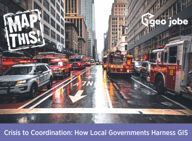
Image Source: Erik Mclean | Pexels Have you ever wondered how local governments can streamline so many different events or emergency responses? It’s because they utilize GIS technology.  GIS, or Geographic Information System, is used in local government in many different ways. It can help first responders locate properties, find the fastest route to an emergency, […]

READ MORE

  • Twitter
  • Facebook
  • Linkedin
  • Youtube
  • Instagram
  • Home

© GEO Jobe (1999-2025). All rights Reserved.
Finely crafted by Proof Branding.

badge-marketplace badge-localgovernment badge-fedsmallbusiness badge-hub esriPlatinumPartner AWS Partner

[hubspot type=”form” portal=”8297964″ id=”c9a3195d-5182-452b-aa0a-dc6816332d9c”]

[hubspot type=”form” portal=”8297964″ id=”8b935646-12aa-40f4-b8a6-2276181e74ed”]

[hubspot type=”form” portal=”8297964″ id=”dd9363a0-a70b-465e-b003-68b97fb0b7f4″]

[hubspot type=”form” portal=”8297964″ id=”efd6624a-7a78-4aae-b931-20bf4968f09c”]

[hubspot type=form portal=8297964 id=6b65713b-ad10-49db-b015-595639756a15]

[hubspot type=form portal=8297964 id=aa47a442-f708-404d-91d8-1aff290d387a]

UAV Information Request

[hubspot type=form portal=8297964 id=f98d99ba-37c8-4bc3-bb12-f64c58d4c5e7]

[hubspot type=form portal=8297964 id=81ce2c26-f3fb-428f-bef2-0fa4850a1b32]