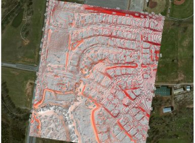
Local governments, utilities, and facility managers have a new resource at their disposal to help keep their GIS land base current and up to date while also saving money. Our latest news release shares details of a UAV orthophoto update project for West Wilson Utilities District, Wilson County. The project has resulted in significant cost […]
Author: GEO Jobe
From our GEOPowered Cloud to custom solutions, GEO Jobe is committed to showing clients how geospatial thinking can guide them to save time, money, and make better business decisions. The power of GIS, Simplified!

News – GEO Jobe to Share “The Power of GIS, Simplified” at 2017 International Esri User Conference
Esri Business Partner, GEO Jobe, will be exhibiting and showcasing ArcGIS Online Solutions and Services including Admin Tools for ArcGIS Online, The GEO Powered Cloud, UAV Mapping Services and more at International ESRIUC – attendees are encouraged to stop by Booth #2438 and hear about GEO Jobe’s solutions and services for ArcGIS Online and witness […]
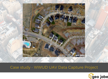
West Wilson Utility District Turns to GEO Jobe for UAV Data Capture & Orthophoto Updates
In order to remain relevant and a leading service and solution provider in the GIS industry for almost 20 years we constantly have a need to adopt new technologies, push the limits, and add complementary tech and services to our offerings. GEO Jobe has been integrating UAV / UAS data capture into a number of […]
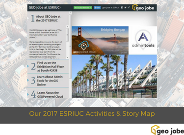
GEO Jobe at the 2017 ESRI User Conference – Our ESRIUC Activities and Announcements Story Map
We’re ready to head to San Diego once again for the Annual International Esri User Conference (ESRIUC) and have shared details of where you can find us, what we will be sharing, and also a couple of events of interest to add to your calendar. Enjoy our ESRIUC plans via this Story Map / Map […]
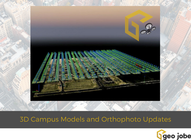
GEO Jobe UAV Services – Producing 3D Campus Models and Digital Orthophoto Updates
GEO Jobe is pleased to share that we offer high resolution low altitude orthophotography services (see geo-jobe.com/uav) and, optionally, hosting options via the GeoPowered Cloud. As part of our services, we are providing orthophoto planimetric mapping products including small area rectified mosaics, digital surface models (DSM), digital terrain models (DTM), and 3D models as well […]

GEO Jobe at 2018 ESRIUC
We are pleased to share that, once again, our team of GIS innovators will be exhibiting at the annual Esri User Conference. The crew will be showcasing ArcGIS Online solutions, UAV services, and GEOPowered Cloud Managed Services for ArcGIS at the 2018 International ESRIUC.

News – GEO Jobe UAV Secures Official FAA Authorization for UAV Mapping Flights on Airport Lands
GEO Jobe UAV Mapping services is conducting UAV/UAS operations at levels few other geospatial technology companies are having success at achieving. GEO Jobe UAV Mapping Services has beaten the odds to receive the hard to come by FAA airspace authorization for UAV missions on designated Airport lands.
Meet the GEO Jobe Team! Developer Spotlight – Ken Doman, Senior Front-End Engineer
GEO Jobe has been serving our clients and partners since 1999 but you may not be too familiar with the faces behind the company. We thought it would be fun to introduce some of the talented crew behind the company to our readers, users, customers, and partners. We’ve shared a short Q & A with […]

GEO Jobe Video – Discussing ArcGIS Open Data with Andrew Turner, CTO Esri R&D
While attending the 2017 Esri DevSummit our @gletham had a brief meetup with Andrew Turner of Esri. Recall, Andrew (@ajturner on Twitter) is the CTO of Esri’s R&D Center in Washington D.C. Andrew’s work focuses on cross-domain collaboration and democratizing the map making process creating open tools for cartography and analysis. Enjoy this early morning […]

GEO Jobe Welcomes Ken Doman to Role as Senior Front-End Engineer
We are pleased to welcome industry veteran, Ken Doman to the team in the role as Front-End Engineer. Doman, based in Chicago, will be working closely with our teams in Nashville, TN, and Biloxi, MS to assist in developing and expanding upon GEO Jobe’s world class products.